|
10/19/2013 3 Comments History at your fingertips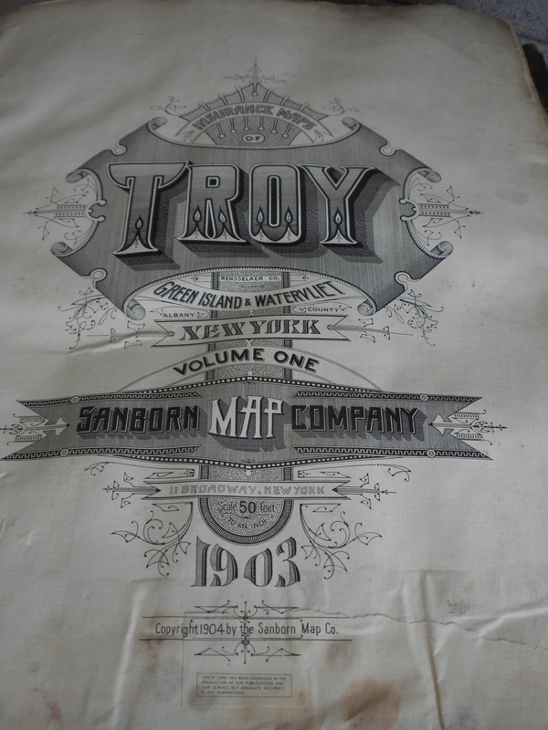
Last week my friend and landlady Debii and I met with Troy's City Engineer Russ Reeves and his assistant, Barb. The city is tearing down the long-abandoned building next door, and Russ wanted to go over the plans with us so we'd know what was happening. The building, which is structurally unsound, needs to be shored up before being demolished, as it is only four feet from our house at the closest point. It is also partially sharing a party wall with the building on the other side, so great care needs to be taken in order to make sure that when the contractors take it down, it doesn't fall down on us, or take the other building with it. We really appreciate Russ' concern, and we greatly appreciate being informed. Let me tell you, that would not happen in New York City. There will certainly be more posts on the teardown as it happens. Meanwhile.... Russ and Barb were still in a meeting when we got there, so he asked us to wait in another office. Deb and I both noticed that there were large atlas-sized books on tables and shelves, and we asked if those were for Troy. Russ took down one for us and we spend a very short fifteen or twenty minutes looking at the books. We were in atlas heaven! I refer to the Sanborn and other insurance company atlases all the time in my research work. In Brooklyn, the Brooklyn Historical Society has a full set of them for Brooklyn, from the mid 1800's up to the early 1900s for on site reference. They are fascinating, as they have an outline for every building on every street in the city. Wood framed structures are in yellow, masonry buildings in a pinkish red. The New York Public Library, among other sources, has many of them on line, and I'm always referring to them in my columns, and in my private research projects. We were looking at the Sanborn map book for Troy, Watervliet, and Green Island, circa 1903. Not only was it a 110 year old volume, it was an original, not a print. These were original outlined drawings, the original hand written lettering in perfect script. There were cut outs and addenda where buildings had been built or torn down, often pasted on top of the old map pages, and the entire book was made of cotton pages with the paper maps pasted onto the pages. You probably could only have made us happier if you had set an illustrated medieval manuscript or the Gutenberg Bible in front of us. These maps are treasures! We looked up our block, of course, but spent a lot of time just looking at how the city has changed in a century. I always knew we were a city of factories and warehouses, but I had no idea how many there actually were. And it was not lost on me that I was standing in one of the largest of those factories. Also it was astonishing to see how much certain areas of the city have changed. I knew "urban renewal" had cut a swath, but wow! These books need to be preserved, restored and treasured. Deb is going to find out from her old museum contacts how that could be done, and if there are grants to do so. You'll be hearing more about these maps in the future. Many thanks to Russ Reeves for the opportunity to see Troy's past in such an immediate way.
3 Comments
Kerry
10/24/2013 01:15:24 am
Hi Suzanne! Let me start of by saying how thrilled I was to find your blog. It is wonderful to see the attention you are bringing to the architectural beauties here right in front of our eyes. I would love if you did a feature on Frear's Troy Cash Bazaar. Keep up the great work it is appreciated! 10/25/2013 12:01:38 pm
I love that I've found another Trojan! That never happens for me in the blog world.
Suzanne
11/2/2013 09:05:48 am
Kerry and Preppy, welcome! I'm glad there are some Trojans reading. I hope you continue! Leave a Reply. |

AuthorMy name is Suzanne Spellen. I've been many things: a writer, historian, preservationist, musician, traveler, designer, sewer, teacher, and tour guide; a long time Brooklynite and now, a proud resident of Troy, NY. Archives
February 2019
Categories
|
 RSS Feed
